


Deskripsi V-Navi
V-Navi - The full-featured navigation app for Android that brings you quicker to your goal! Works in conjuction with various apps (e.g., "Das Telefonbuch", "Das Örtliche", among others), even free of charge, as conditions may apply.
ATTENTION: Navigation can be started in Germany, Austria, Switzerland and optional in Western Europe.
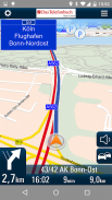
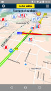
With the high quality traffic you will get a complete overview of the market. Traffic congestion traffic congestion avoidance. The V-Navi: you will thus always the best route. The traffic density is displayed in red, yellow, green in the map. Germany, Annual, 30 days free of charge with no obligation to buy. Internet connection is required.
The new version of V-Navi works with offboard maps (with limited functionality) to enable immediate navigation after download. The map data for Germany, Austria and Switzerland is downloaded once at the start of the first use of V-Navi (ca. 300 MB). Thereafter, an Internet connection is only necessary for a short time at app-startup.
HIGHLIGHTS:
- Current traffic situation in Germany (INRIX), traffic reports traffic congestion avoidance and traffic density display
- Offboard vector mode after first installation
- Lane info assistant
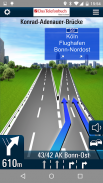
- Reality view (reality like display of turn actions on motorways)
- Map data is stored on the device
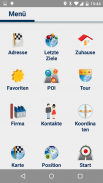
- Quick destination entry (address, points of interest (POIs), favorites, etc.)
- Updates free of charge
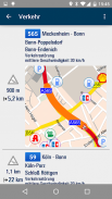
- Computation and display of alternate routes
- Display of speed limits and speeding alerts
- Support for portrait and landscape display
- Quick-Menu
- New and ergonomic menu
- Optimized map view
- Save & load itineraries
FUNCTIONS:
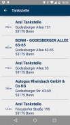
Destination entry:
- Address entry with an automatic pop-up list of cities, etc.
- Address search by country
- House-number-exact geocoding when online
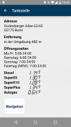
- POI search
- Destination selection directly on the map
- Entry of destination coordinates and crossroads
- Destination selection from a list of recent destinations and from the favorites list
- Use of contacts in the address book as destinations
Navigation:
- Profiles for car, pedestrians, recreational vehicles and caravans
- Adjustable routing: quickest, shortest
- Voice-guided navigation
- Spoken street names through text-to-speech
- Sinage display (motorway signs)
- Speed-dependent zoom and crossroad-zoom
- Stretch-block: Automatic route recalculation (e.g., for the next 0.5-10 km along the route to avoid a traffic jam)
- Avoidance of motorways, ferries, and tollways
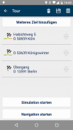
- Itineraries: Management of intermediate stops, saving and loading of itineraries
Map Display and Functionality
- View modes: 3D, 2D in the direction of travel, 2D North up
- Daytime and nighttime view modes, automatic switching (geodaylight)
- Route overview
- Display of POIs with setting of the destination directly from a POI icon on the map
CONDITIONS OF USE:
V-Navi may be used free of charge for a test period of 30 days. Numerous applications, such as the telephone directory apps "Das Telefonbuch" and "Das Örtliche" provide you with the means of continuing to use V-Navi free of charge by starting V-Navi directly from within the apps. Please consult the Conditions of Use in each of the respective apps.
The traffic data to 30 days (trial period) are free to use and are then as in-app purchase.
AVAILABLE in-app purchase options (for pricing, see under "In-App Purchases"):
- Traffic data for Germany (INRIX)
- Navigation und maps for Germany, Austria, and Switzerland (D-A-CH)
- Navigation und maps for Western Europe
The map data and navigation for Western Europe cover the following countries:
Germany (D),Austria (A),Switzerland (CH),Liechtenstein,Andorra,Belgium,Denmark,Finnland,France,Great Britain,Ireland,Italy,Luxemburg,Monaco,Netherlands,Norway,Portugal,San Marino,Spain,Sweden
See more at https://www.facebook.com/Map-and-Route-1454577274845960/
V-Navi - Aplikasi navigasi fitur lengkap untuk Android yang membawa Anda lebih cepat ke tujuan Anda! Bekerja dalam conjuction dengan berbagai aplikasi (misalnya, "Das Telefonbuch", "Das örtliche", antara lain), bahkan gratis, karena kondisi mungkin berlaku.
PERHATIAN: Navigasi dapat dimulai di Jerman, Austria, Swiss dan opsional di Eropa Barat.
Dengan lalu lintas berkualitas tinggi Anda akan mendapatkan gambaran lengkap dari pasar. Kemacetan lalu lintas kemacetan lalu lintas penghindaran. V-Navi: Anda akan demikian selalu rute terbaik. Kepadatan lalu lintas ditampilkan dalam warna merah, kuning, hijau di peta. Jerman, Tahunan, 30 hari gratis tanpa kewajiban untuk membeli. koneksi internet diperlukan.
Versi baru dari V-Navi bekerja dengan peta offboard (dengan fungsi terbatas) untuk mengaktifkan menu segera setelah download. Data peta untuk Jerman, Austria dan Swiss-download sekali pada awal dari penggunaan pertama dari V-Navi (ca. 300 MB). Setelah itu, koneksi internet hanya diperlukan untuk waktu yang singkat di app-startup.
HIGHLIGHT:
- Situasi lalu lintas terkini di Jerman (Inrix), lalu lintas melaporkan kemacetan lalu lintas penghindaran dan kepadatan lalu lintas display
- Modus vektor Offboard setelah instalasi pertama
- Info Lane asisten
- Lihat Reality (realitas seperti display tindakan turn di jalan raya)
- Peta data disimpan pada perangkat
- Entri tujuan Cepat (alamat, tempat tujuan (POI), favorit, dll)
- Update gratis
- Perhitungan dan tampilan rute alternatif
- Tampilan batas kecepatan dan alert ngebut
- Dukungan untuk portrait dan landscape display
- Cepat-Menu
- Baru dan menu ergonomis
- Peta Dioptimalkan
- Simpan & beban perjalanan
FUNGSI:
entri tujuan:
- Alamat entri dengan daftar pop-up otomatis kota, dll
- Pencarian Alamat oleh negara
- Rumah-nomor-yang sebenarnya geocoding ketika secara online
- POI pencarian
- Pilihan tujuan langsung pada peta
- Masuknya tujuan koordinat dan persimpangan jalan
- Pilihan tujuan dari daftar tujuan baru dan dari daftar favorit
- Gunakan kontak di buku alamat tujuan
Navigasi:
- Profil untuk mobil, pejalan kaki, kendaraan rekreasi dan karavan
- Adjustable Routing: tercepat, terpendek
- Navigasi panduan suara
- Disampaikan nama jalan melalui text-to-speech
- Display sinage (tanda-tanda jalan tol)
- Zoom Kecepatan tergantung dan perempatan-zoom
- Stretch-blok: Otomatis dengan perhitungan kembali (misalnya, untuk 0,5-10 km sebelah sepanjang rute untuk menghindari kemacetan lalu lintas)
- Menghindari jalan raya, feri, dan Tollways
- Rute perjalanan: Manajemen berhenti menengah, tabungan dan pemuatan perjalanan
Peta Tampilan dan Fungsi
- View mode: 3D, 2D dalam arah perjalanan, 2D Utara up
- Daytime dan melihat malam mode, switching otomatis (geodaylight)
- Ikhtisar rute
- Tampilan POI dengan pengaturan dari tujuan langsung dari ikon POI di peta
KONDISI PENGGUNAAN:
V-Navi dapat digunakan secara gratis untuk jangka waktu uji 30 hari. Berbagai aplikasi, seperti telepon direktori aplikasi "Das Telefonbuch" dan "Das örtliche" menyediakan Anda dengan cara terus menggunakan V-Navi gratis dengan memulai V-Navi langsung dari dalam aplikasi. Silahkan baca Ketentuan Penggunaan di masing-masing aplikasi masing-masing.
Data lalu lintas ke 30 hari (masa percobaan) bebas untuk menggunakan dan kemudian sebagai pembelian di-app.
TERSEDIA dalam aplikasi pilihan pembelian (untuk harga, lihat di bawah "In-App Pembelian"):
- Data Lalu Lintas untuk Jerman (Inrix)
- Navigasi und peta untuk Jerman, Austria, dan Swiss (D-A-CH)
- Peta und Navigasi untuk Eropa Barat
Data peta dan navigasi untuk Eropa Barat mencakup negara-negara berikut:
Jerman (D), Austria (A), Swiss (CH), Liechtenstein, Andorra, Belgia, Denmark, Finnland, Perancis, Inggris, Irlandia, Italia, Luxemburg, Monako, Belanda, Norwegia, Portugal, San Marino, Spanyol, Swedia
Lihat lebih lanjut di https://www.facebook.com/Map-and-Route-1454577274845960/
V-Navi - The full-featured navigation app for Android that brings you quicker to your goal! Works in conjuction with various apps (e.g., "Das Telefonbuch", "Das Örtliche", among others), even free of charge, as conditions may apply.
ATTENTION: Navigation can be started in Germany, Austria, Switzerland and optional in Western Europe.
With the high quality traffic you will get a complete overview of the market. Traffic congestion traffic congestion avoidance. The V-Navi: you will thus always the best route. The traffic density is displayed in red, yellow, green in the map. Germany, Annual, 30 days free of charge with no obligation to buy. Internet connection is required.
The new version of V-Navi works with offboard maps (with limited functionality) to enable immediate navigation after download. The map data for Germany, Austria and Switzerland is downloaded once at the start of the first use of V-Navi (ca. 300 MB). Thereafter, an Internet connection is only necessary for a short time at app-startup.
HIGHLIGHTS:
- Current traffic situation in Germany (INRIX), traffic reports traffic congestion avoidance and traffic density display
- Offboard vector mode after first installation
- Lane info assistant
- Reality view (reality like display of turn actions on motorways)
- Map data is stored on the device
- Quick destination entry (address, points of interest (POIs), favorites, etc.)
- Updates free of charge
- Computation and display of alternate routes
- Display of speed limits and speeding alerts
- Support for portrait and landscape display
- Quick-Menu
- New and ergonomic menu
- Optimized map view
- Save & load itineraries
FUNCTIONS:
Destination entry:
- Address entry with an automatic pop-up list of cities, etc.
- Address search by country
- House-number-exact geocoding when online
- POI search
- Destination selection directly on the map
- Entry of destination coordinates and crossroads
- Destination selection from a list of recent destinations and from the favorites list
- Use of contacts in the address book as destinations
Navigation:
- Profiles for car, pedestrians, recreational vehicles and caravans
- Adjustable routing: quickest, shortest
- Voice-guided navigation
- Spoken street names through text-to-speech
- Sinage display (motorway signs)
- Speed-dependent zoom and crossroad-zoom
- Stretch-block: Automatic route recalculation (e.g., for the next 0.5-10 km along the route to avoid a traffic jam)
- Avoidance of motorways, ferries, and tollways
- Itineraries: Management of intermediate stops, saving and loading of itineraries
Map Display and Functionality
- View modes: 3D, 2D in the direction of travel, 2D North up
- Daytime and nighttime view modes, automatic switching (geodaylight)
- Route overview
- Display of POIs with setting of the destination directly from a POI icon on the map
CONDITIONS OF USE:
V-Navi may be used free of charge for a test period of 30 days. Numerous applications, such as the telephone directory apps "Das Telefonbuch" and "Das Örtliche" provide you with the means of continuing to use V-Navi free of charge by starting V-Navi directly from within the apps. Please consult the Conditions of Use in each of the respective apps.
The traffic data to 30 days (trial period) are free to use and are then as in-app purchase.
AVAILABLE in-app purchase options (for pricing, see under "In-App Purchases"):
- Traffic data for Germany (INRIX)
- Navigation und maps for Germany, Austria, and Switzerland (D-A-CH)
- Navigation und maps for Western Europe
The map data and navigation for Western Europe cover the following countries:
Germany (D),Austria (A),Switzerland (CH),Liechtenstein,Andorra,Belgium,Denmark,Finnland,France,Great Britain,Ireland,Italy,Luxemburg,Monaco,Netherlands,Norway,Portugal,San Marino,Spain,Sweden
See more at https://www.facebook.com/Map-and-Route-1454577274845960/
V-Navi - Versi 4.9.7
(16-06-2020)
V-Navi - Informasi APK
Versi APK: 4.9.7Paket: de.mapandroute.android.vnaviAplikasi pada kategori yang sama
Anda juga mungkin suka...


